Marble canyon to Roger Creek (Duffey Lake Road) 81km Total 864
Last night, I decided to use the camping gear that I have been dragging over the mountain-tops for the last week. Yes, I could have made my life easier by packing it in the Yalie (or even by leaving it at home) but this is a proof-of-concept for the longer, unsupported trip that I am planning, so I am persevering.
I slept comfortably in my Hubba tent, and in the morning made porridge on my little stove, though I must admit that Valerie handed me a steaming cup of coffee from the Yalie.
 The route to Lillooet is generally downhill, but as usual, those pesky engineers have inserted some stiff climbs. Much of the land here is First Nations reservation, including the hamlet of Pavilion, which was the jumping-off point for a cross-country diving trip that we made to Bella Coola a few years ago… but that’s another story.

The CN railway to Northern BC parallels the road, with spectacular, unrelenting grades. You wonder how a train can climb this line; I’m certainly glad to be going downhill on this route.
Our plan was to meet in Lillooet, but after waiting for two hours in a cafe filling up with meat pies and sandwiches, I was getting a little concerned. Turns out that Valerie’s travelling ministry was in action again, she had rescued a family whose car had broken down, miles from anywhere. They had been trying to flag a passing car, but Valerie was the only driver that would stop. She has a kind heart. She gave the mother, Simona, a ride (80 km round trip) to a place where she could use her phone, and then took her back to the family to wait for a mechanic. The family were First Nations people from the Stein Band. Valerie had a wonderful conversation with Simona, and learned that in spite of the difference in background, their lives had many parallels. Of course, she left them with a stack of PB sandwiches, water, grapes, apples and oranges to sustain them, as well as hugs all around.
During their conversation, Simona mentioned that they had seen me on the road earlier, and a big black bear had run across the road right behind me. I hadn’t even seen him!
After we finally made contact (by voice mail) we both headed out along the Duffy lake road to find our next camping spot, about 30 km on. I have heard this road described as a challenging ride, but that doesn’t say half of it. The first 6 km are a series of switchbacks that reach 13% grade. I was able to struggle up that section, with numerous rest stops, but by that time my legs were toast. And that’s only the first part! The road just climbs and climbs into the forest, with just enough steep downhill sections to make sure that even turning back would not stop the pain. Way steeper than anything else I have seen on this trip, or anywhere else for that matter. Eventually, I just had to say “uncle”, and get off and push for a couple of km.
And just when I was starting to wonder if I had got in over my head this time, the road started to level out, at least to the same gradient as the roaring Cayoosh Creek that had created this spectacular valley.
I finally caught up with Valerie, who had found a good camp site and was just getting ready to drive back and look for me. She was parked by the side of the road preparing yet another wonderful dinner. Bless her.
Nearly 5 hours to cover 30 km. But when it’s over, it feels so fantastic.
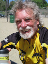
A cold beer and a plunge in the creek, and I’m as good as new. This for my sister Janet: you asked me to include a photo without helmet and sunglasses. Here goes…


"Nearly 5 hours to cover 30 km". That' some hard riding Barney. Thanks for the blog. For the map and for the pix. Following you all the way. Love to Val.
ReplyDelete